Saturday, March 12, 2016

New hiking book is now available!

I finished my book about my 7 year hiking adventure on the Idaho Centennial Trail.   It is titled                      "The Search for the Flat Ness Monster."    It is available in paper and as an e-book.


It is available at Amazon.com,  Barnes and Noble, and Authorhouse.com.     


Saturday, January 9, 2016

Welcome to 2016

I haven't updated this in a long time.  I've been busy walking.   I finished 2015 with 1,006 miles of walking.  4th consecutive year to break 1,000, and I set a new record by 1 mile.  

I need to go back and back fill my blog for 2015.   There were many interesting new places I hiked that I want to share.  

Here is my updated hiking map for hiking across Idaho.      A lot of what I worked on in 2015 was the southern leg of my proposed "Great Eastern Loop."   I started at the southern end of the Idaho Centennial Trail back in February and extended east as far as Interstate 84.   During July I hiked from the eastern shore of Bear Lake in southeast Idaho as far west as the town of Weston.   There are about 76 miles remaining to close the gap of the southern section.  

Wednesday, April 1, 2015

ICT Lochsa River highway 12


13 mile hike along the Lochsa River from Wilderness Gateway Campground to

Split Creek Pack Bridge.


July of 2008


Wednesday, March 25, 2015

THREE CREEK ROAD

the last 2 weekends   ( March 15-16  and March 22-24)   I have put in 53 miles of hiking in southern Idaho.    the town of Rogerson, Idaho has been my base for food and supplies.    The first installment was 6 miles (x2) to the east of Rogerson, on Shoshone Basin Road.    

next section was 47 miles from the beginning of the Idaho Centennial Trail  south terminus heading east on Three Creek Road.    it was pavement all the way.    The attached map shows my route.  

Darwin Clampitt helped with shuttle duties.   I parked my car in Rogerson, and Darwin dropped me off at the western end of the hike.    Sunday afternoon I hiked 16 miles, the first 10 of which were without my pack and gallon water jug.    I camped beside the road Sunday night.    It was very windy and rained some near dawn.

Monday was a 24 mile day.   The wind blew hard all day.   Thankfully, it was at my back for the entire route.    Waves of snow showers came through about every hour, each one progressively stronger.   After 6 hours of walking, I stopped for a break.   I put my tarp against a barbed wire corner post to hunker down against the wind.    As soon as I stopped moving I began to get cold.   However, I needed the rest and the lunch break.    After an hour rest, I moved on.   I walked another 4 hours to get to Salmon Falls Creek Reservoir and the Lud Drexler campground.    

Once again, as soon as I stopped moving, I stopped generating warmth.   It was getting cold and I was concerned about staying warm.    For the first time ever in my hiking career, I camped for the night in a bathroom.    It was a pit toilet, but it was one of the handicapped sized versions.   The floor was clean.   I was a bit on the desperate side.    I knew I was in the beginning stages of hypothermia.   It was a matter of survival.    Getting inside immediately got me out of the wind.   Wearing just about every article of clothing, with my new down booties and my snow cap, and my hood, and Underarmor gloves, with the sleeping quilt made by my wife and my Thermarest mattress beneath me, I was able to get warmed up and stay warm (mostly) all night.  

It was a much needed rest after a 24 mile day.    In the middle of the night, I though there were bears in the garbage dumpsters, because they kept banging around.   When I got up and looked out in the morning, I saw that it had been raining and it was still very windy.   The wind must have been rattling the dumpsters.  

I walked the remaining 7 miles into Rogerson, still with a strong wind at my back.  

I learned some very interesting history about the area and the Jarbidge Canyon area from a very knowledgeable lady at the cafe'.    The cheeseburger was to die for, by the way!  


Friday, February 20, 2015

Walking a Stateline part 06

Stateline Trail part 06
a *miscellaneous* video of some road walking sections of the Idaho Centennial Trail along the Idaho-Montana Stateline Trail. I had vehicle support for these sections. The first part is between FR 506 "Route of the Hiawatha" bike path along FR 391 to FR 305 near Dominion Peak. The second part is a road walk between the Stevens Lakes and Lost Lake trailhead down across Interstate 90 to Larson Road.
Chronologically, these hikes took place the day before the hike shown in Part 05 "The St. Regis Gambit."
Tyler Parrish and Cody Wolter were my chase team.
I created this video with the YouTube Video Editor 


Tuesday, December 23, 2014

ICT TOWING PAINS 2008

"The best laid plans of mice and men....." What happens when one of the shuttle vehicles goes out of commision?

This was a planned 40 mile hike on the Idaho Centennial Trail in August of 2008. My 93 Aerostar minivan died at the takeout trailhead, which was Five Mile Pond on the Crooked River Road. Our plans for a one way hike together were busted. Using Jerry's vehicle I drove him around to the other end at Rocky Bluff Campground, on Slate Creek. He would now hike solo across the 40 mile stretch, going roughly Counter Clockwise around the western and northern edges of the Gospel Hump Wilderness.

While my van was being towed and repaired, I would camp at Five Mile Pond on the other end, and wait for Jerry. I had 3 days of time to kill.

Inspiration came to "improvise" a new hike while I waited for him. I needed to make a connection between Five Mile Pond on one end, and French Gulch on the other end. 19 miles going, 18 miles coming back. Since Jerry had problems with the ICT section in between on his previous hike, I planned a long road walk around, using an existing network of Forest Service and discontinued roads.


Thursday, December 18, 2014

Mt. Heinen

exploring Bald Mountain Road, south of Idaho City. 12-10-14
6,396 foot Mt. Heinen is in the background.  
1st pic is Tyler my son-in-law.     2nd pic is me.


Tuesday, November 11, 2014

Dutch Creek

the view from the hillside at Dutch Creek, where we placed our "Dutch Army" geocache.      This view is looking to the south towards Arrowrock Reservoir.  


First Geocache

Tyler (my son-in-law)   and I made our first geocache location today! 

if you go to co-ordinates N 43 deg 36' 17.08" W 115 deg 53' 05.52" you can find our cache at Dutch Creek. 

We named it "Dutch Army"

the reason for the name?   the cache is a small ammunition box, with a plastic container inside filled with plastic army men.   One of the traditions of the geocache, although not always required, is that there are small items inside.   Finders can trade a small item, such as a coin, pen, business card, belly button lint, etc.  for one of the items inside.   We put our email addresses in the logbook, asking finders to send us an email telling us where the "Dutch army" has travelled.   

The cache is placed at Dutch Creek, hence the name "Dutch Army."

it should appear soon on the www.geocaching.com website.

see image below


Wednesday, November 5, 2014

HANG GLIDER HILL

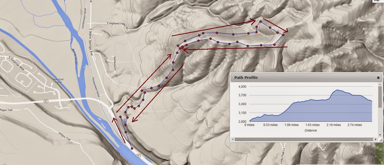
Today I made about a 4 1/2 mile loop up and back in the Boise foothills.   

I don't know the name of this hill, but it is the hill where the hang glider folks launch from. 

It is in east Boise, up near Hammer Flats.  

Today I did some exploring up there.   The road is very steep going up to the ridge, but the view is very rewarding.   It was awesome.   There is quite a view of the valley.  The trees are just about peak color now.

It is easy to see, from the ridge, why the hill is popular for hang gliding.   The ridge itself is about 10 feet wide, relatively flat with a trail, with both sides gradually sloping down to a precipitous drop off.   The curvature is ideal for someone to make a running start with their hang glider, going downhill, and launching from the edge out over an expansive valley.    

I continued on up the ridge, and took a side trail, which was really just a terrace contoured along the hill.   It might have been an old fire break line.  The single track was fairly well defined and easy to follow.   I could trace the contour ahead for at least 2 or 3 miles around the steadily rising ridge.  

When I got around on the back side of the ridge, it was SO quiet!    It always amazes me how such vast distances can be so silent and peaceful.   I took a beeline up the hill and connected to the road/path along the top of the ridge and followed it back to the hang glider launching section.   From there I came back down the same path to the car, parked near Diversion Dam.

I would like to continue on up the ridge and make the connection to Highland Valley Road, and then continue on up to the summit of Lucky Peak.   

The climb was a good test of my injured ankle.   It did really well, with my neoprene compression sock.  

see the attached map for my path today....


Sunday, October 12, 2014

Fall down go BOOM!

video taken by Jerry Finnegan. August 31st, 2014 on the Idaho Centennial Trail, East alternate section. we had climbed 5 miles on the Alturas-Mattingly trail starting at Alturas Lake. we reached the ICT trail going to Ross Fork, then turned on the Johnson Creek trail.

Only a mile or so down this new trail, I took a sudden spill. My ankle rolled and I went rolling down the hill. I did a complete somersault and landed on my back with my feet facing downhill.

Jerry was ahead of me on the trail. He took the video about 30 seconds after I fell.

Fortunately my ankle was only a strain instead of a sprain. I still had to backpack another 11 miles out on rugged trails to get to a road where we could make contact with home.


http://youtu.be/WG-ryQ4-z7Y?list=UUePBvxGwStEPcCEUHZrPE-w


Sunday, September 28, 2014

Kryptonite

Green Kryptonite was the bane of Superman, a substance that sapped his powers and made him a helpless weakling.

I took a picture of this plant on Sunday 9/28/14 along the Greenbelt, near the Boise River.   

I call it "Ron's Kryptonite."   other folks call it "Sagebrush."   this is what it looks like in full bloom.  

I am highly allergic to it.  

here in Idaho,  it blooms generally between the last week of August, through September, and up to the first couple of hard freezes in October.    

when we first moved here, I had to take a year of allergy shots. part of the serum was sagebrush pollen.    the immuno-therapy helped, for the most part, but this is the time of year when I rely heavily on Vitamin Z  (Zyrtec).  


Tuesday, September 23, 2014

the Soggyway and the Bitter Pill

sometimes things just don't go your way.   this is a sad chapter in the story of my seven year hike across Idaho.   we were going to attempt to do one big knockout punch on the Selway-Bitterroot Wilderness.   we being myself, Kim Heintzman, and Nick Abshire.   we attempted a 95 mile hike.   an entire day of hiking in the rain and a non functioning satellite phone changed the plan.   Then we still had to walk 40 miles out to rescue ourselves.  


song credits go to


"Trial of Tears" by Dream Theater  (split into 2 parts)


http://www.dreamtheater.net


and


"Minor Setback"

by Acaideus


Monday, September 22, 2014

Upper Priest Falls

the rain forest like environment of northern Idaho is a wonderful contrast to the high desert environment of southern Idaho.  


for this video segment of the Idaho Centennial Trail, I used a different approach. instead of a face-melting rock soundtrack, I chose a "jungle" theme. I had a lot of fun putting this one together. This is the next to the last segment of the trail, in the Idaho panhandle north of Priest Lake. July of 2011.


1


Wednesday, September 10, 2014

ROLLED ANKLE

this is the bruising about four days after rolling the ankle.  


ICT East alternate route

it was planned as a 30+ mile section of the Idaho Centennial Trail, East alternate route, from near
Alturas Lake, through Johnson Creek, over to Emma Creek, up Emma Creek to Big Smoky Creek, then down FR215 to Highway 75 below Galena Summit.   Jerry and I planned it for Labor Day weekend.   We started on Sunday, August 31st, at the trailhead near Alturas Lake.   things went well for the first 6 miles or so.  We reached the Idaho Centennial Trail near Mattingly Divide, and were on the main ICT for just a half mile or so before reaching the junction with the ICT East trail going into the Johnson Creek drainage.   About a mile and half down this trail, my ankle suddenly gave way beneath me.   My momentum caused me to do a complete somersault, and I landed on my back with my feet facing down the slope.   Fortunately I didn't continue to roll.   The damage was done, however.   My ankle was severely strained though not broken.   Through the rest of the afternoon I hobbled on down the trail.   Our campsite was not the greatest (see previous post) and the next morning we continued on.   We had accepted that we would not get done by Tuesday and were trying to figure out how to get a message out to our wives.    As the day progressed, it became apparent that I was not going to get even to the half way point of the hike.   We decided to come off the trail at Emma Creek, where it meets the South Fork of the Boise road (NFD road 079).      We were helped by Roger and Mary Ann on their ATV.   They got us down the road to a Methodist church camp where we were able to send messages out by satellite internet.   Jerry's wife and son came to the rescue.    Sometimes it's better to live to hike another day......


pictures here....

share.shutterfly.com/action/welcome?sid=0ActGbJq2YsWrDTA


Monday, September 8, 2014

Site selection


Sometimes home for the night is what you make of it. 

Not the most ideal sleeping spot. this person-sized depression up slope from a tree was where I made camp. 

Jerry's spot down the hill from me was only slightly better.


 I need to improve at taking "selfies", but this is the morning after I rolled my ankle and the pain is showing through. this shot shows the angle of the slope. Believe it or not this was the best camp location we could find in that stretch of trail


Wednesday, August 6, 2014

Better than Television

This particular evening, the campfire is more for entertainment value than warmth......


Monday, July 21, 2014

Lick Creek Road

this is the start of another walking project 

on Saturday I drove up to McCall, then about 30 miles east on Lick Creek Road, as far as the Secesh River.    This is where the ICT crosses the road at Ponderosa Campground.   

I mapped out an 11 mile stretch of Lick Creek Road, starting from the ICT, to the west up to the summit of Lick Creek Road.    Elevation gain is about 2,400 feet.

walked 6 miles (3 x 2) Saturday evening, and found a free campsite with a fire ring!   the campfire was more for entertainment value than for warmth.   a campfire is way better than television any day!


on Sunday I walked the remaining 16 miles (8 x 2) up to the summit and back.   The road was not terribly steep, it was just a steady grade uphill.    I moved the car three times, each time walking up roughly an hour and then back.   


Wednesday, July 2, 2014

Meal preparation

DIY dehydrated meals

here is my meal preparation for an upcoming hike.

there are 5 meals, and 5x2 = 10 grits packets for 5 breakfasts.

each meal has 2 cups each of the dehydrated soup + 1 cup of Minute Rice

the flavors are 1 Black Bean soup  1 Pilaf Chicken  2  Tortilla soup  1  White Bean & Pasta

the flavor packets are inside the bags. 

for a couple of them I added an extra half scoop of rice. 

they can be rehydrated directly in the ziploc bags, but from experience they are a pain to eat out of.   that's why I carry a "My Fair Share"  32 ounce Lexan cup.   

all I do is boil water and stir. 

season with salsa packets or Tabasco.